Himlung Expedition

Himlung Expedition

Above 7000m, Mountaineering
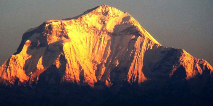
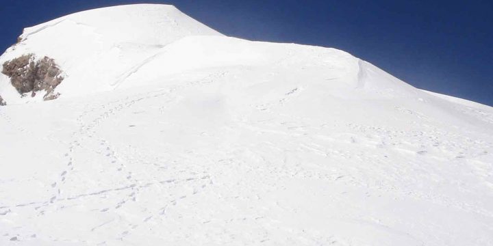
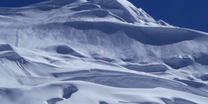
Trip Introduction: Himlung Expedition is a newly opened expedition that takes you to Mt. Himlung (7126 m). It is located near the Tibetan border between Manaslu and Annapurna ranges, in a secluded area. The expedition journey takes you through a small village of Koto towards an interesting Tibetan village of  Phu. The trekking route from Manang to Phu village is remote and untouched as very few tourists have explored this part of Nepal. The landscape is mostly composed of high peaks, passes, glaciers, narrow gullies, forests, and ancient villages. While trekking, we also come across some Buddhist monasteries and have a chance to experience a unique culture and traditional lifestyle of the local people. In addition, we also enjoy the spectacular views of Mt. Manaslu, Mt. Annapurna, Mt. Gangapurna, and many…
Read More
Nanga Parbat Expedition

Nanga Parbat Expedition

Above 8000m, Pakistan Mountaineering
Trip Introduction: Nanga Parbat Expedition takes us to northern Pakistan. Nanga Parbat (8,126 m) is the ninth highest after Mt. Manaslu. It is also the 14th most prominent mountain in the world. Located in Gilgit -Baltistan region of Pakistan this mountain derives its name from Sanskrit meaning "Naked Mountain”. The Mountain: Nanga Parbat Nanga Parbat has three faces,  Rakhiot Face (North), Diamir face (West) and Rupal face (South). A silver plateau dominates the Rakhiot face while the Diamir face is rocky at the beginning but gradually turns into ice fields around the peak. The Rupal face is considered as the highest ice wall in the world. It is 4,600m from the base of the mountain to the peak. Reinhold Messner, a living mountaineering legend from Italy, once said that "everyone…
Read More
Mt. K2 Expedition

Mt. K2 Expedition

Above 8000m, Pakistan Mountaineering
Trip Introduction: Mt K2 Expedition to the second highest peak, 8,611m / 28,251ft situated in Pakistan. It is just  784 feet shorter than Mt Everest. Mt. K2 has long been known as the mountaineer’s mountain. The sharp triangle of its silhouette and height above the surrounding terrain not only define the archetypal image of a mountain but also make K2 far more difficult and dangerous to climb. Truly speaking, technically it is a rather difficult summit than Everest. The Abruzzi Spur is the most popular route while climbing Mt. K2. Mt K2 Expedition: The Route Climbing via the Abruzzi Spur many international expedition teams have succeeded in ascending K2. The route leads us about 300 ft. up steep wind-packed snow towards the summit ridge. From the summit of K2, we…
Read More
Broad Peak Expedition

Broad Peak Expedition

Above 8000m, Pakistan Mountaineering
Trip Introduction: Broad Peak Expedition by Himalayan Global Expedition to Broad Peak in Kangri which is the 12th highest peak. It stands tall at an altitude of 8047m. Also known as Falchan Kangri, this mountain is located along the western Baltoro glacier between K2 and Gasherbrum IV in the Karakoram Range in Northeastern Pakistan. British explorer W.M. Conway named this mountain in 1892 after the similarly named peak in the Alps known as Breithorn. Broad Peak is regarded as the easiest 8000m peak to climb in Pakistan. Most of the climbers use Broad Peak as an acclimatizing mountain for K2.  The route from Broad Peak base camp to K2 base camp is just around one and a half hours away. The mountain has several prominent summits like Broad Peak (8,047m),…
Read More
Gasherbrum I Expedition

Gasherbrum I Expedition

Above 8000m, Pakistan Mountaineering
Trip Introduction: Gasherbrum I Expedition to the "Shining Wall", as the mountain is often called, is the highest (8,068m/26,470ft) among the six peaks of the huge massif. It is one of the prominent peak of Pakistan with K2, Broad Peak, Nanga Parbat among others. This mountain was also named as ‘Hidden Peak’ by the nineteenth-century British explorer Conway. There are six Gasherbrum Peaks and the Hidden peak is the highest. It is the world’s eleventh highest peak with challenging technical difficulties at lower levels. Its first part of the climb is in steep snow. Subsequently, ice with rocks than an easy climb atop snow with mixed slops. The most common route is North West Face. It is located in the Pakistani and Chinese border in Gilgit–Baltistan region of Pakistan and…
Read More
Gasherbrum II Expedition

Gasherbrum II Expedition

Above 8000m, Pakistan Mountaineering
Trip Information: Gasherbrum II Expedition (also known as K4) is the 13th highest mountain and one of the popular 8,000m peaks in the world at 8,035 meters (26,362 ft) above sea level. It is the third-highest peak of the Gasherbrum massif and is located in the Karakoram range, on the border between Gilgit–Baltistan province, Pakistan, and Xinjiang, China. This is a difficult mountain slightly harder than Mt. Cho Oyu but relatively one of the up-front and climbable peaks. .However, it is an ideal training peak for Everest. The climbing on Gasherbrum 2 is not especially steep but the remoteness of the setting makes this an especially rewarding experience. Gasherbrum II Expedition: the climbig route The route that we follow for Gasherbrum II expedition is via the SW ridge. This route…
Read More
Annapurna I Expedition

Annapurna I Expedition

Above 8000m, Mountaineering
Trip Introduction: Annapurna I Expedition (8091m) is the tenth highest mountain in the world. It is located east of a Kali Gandaki Gorge where Kali Gandaki river flows through. The mountain has glaciers on its western and northwest slopes which subsequently drain into this river. The name Annapurna supposedly means “Goddess of the Harvests.” Annapurna I  is known as the world's most dangerous mountains to climb because it is prone to avalanches. It has a high fatality rate. Maurice Herzong and Louis Lachenal, of a French expedition, first climbed this 8,091m peak on June 3, 1950. Similarly, Chris Bonington along with alpinist Ian Clough led the British expedition in 1970. They were the first to climb the south face of Annapurna. Ian Clough, sadly perished on the descent when a…
Read More
Dhaulagiri Expedition

Dhaulagiri Expedition

Above 8000m, Mountaineering
Trip Introduction: Dhaulagiri Expedition to this 8167 m Himalayan massif is the seventh highest mountain in the world. It is located in north central part of Nepal. The crest of the mountain stretches some thirty miles giving structure to an otherwise tangled topography of twisting ridges, glaciers and icefall. Along the main crest, several pyramid-shaped peaks rise. All four of these peaks each rises 7000m over the Kali Gandaki gorge to the southeast within about 30km. The Kali Gandaki gorge lies between Dhaulagiri and Annapurna. This creates a face-off of two eight-thousander giants over the deep Kali Gandaki valley. Dhaulagiri Expedition: an unforgettable climb Although the British surveyors in India first sighted Mt Dhaulagiri in the early 1800s, the mountain remained unknown. A Swiss aerial survey in 1949 truly brought…
Read More
Putha Hiunchuli Expedition

Putha Hiunchuli Expedition

Above 7000m, Mountaineering
Trip Introduction: Expedition to Putha Hiunchuli (7246m), one of the most beautiful mountains over 7000m in Nepal. It is the extension peak of the Dhaulagiri range referred to as Dhaulagiri VII. The landscape of the Dhaulagiri region is enchanting being a snow-capped mountain range with high cliffs and deep canyons. Expedition to Putha Hiunchuli Legendary climber Jimmy Roberts and Ang Nyima first climbed Putha Hinchuli from the northeast route in the year 1954. Climbing Putha Hiunchuli is indeed challenging but technically not so difficult. It is an ideal mountain for those who want to climb high but on moderate terrain. It is an alternative climb to Baruntse peak which is also over 7,000m. Putha Hiunchuli is most accessible from the Kaya Khola, a side-stream of the Barbung Khola which flows…
Read More
Lhotse Expedition

Lhotse Expedition

Above 8000m, Mountaineering
Trip Introduction: Lhotse Expedition to the fourth highest mountain in the world is a very rewarding experience. It is located opposite of Mt Everest’s South Face in the Everest region, Nepal. The South Col actually connects Mt Everest and Lhotse with each other. Expeditions follow the same route across the Khumbu Ice Fall and the Western Crown to camp 3 at the Lhotse face. On the way to Everest's Camp 4, just above the Yellow Band, the Lhotse route takes another direction. Some very strong climbers have even climbed Lhotse and Mt Everest in one, long expedition. But for most of us, Lhotse is a great, single very high mountain to climb, very close to Everest. Many climbers agree that Lhotse is more difficult to climb than Everest due to…
Read More